Final Map and Report Adopted
| File Name | Download Link |
|---|---|
| 2021 Redistricting RRCC Split Parcel Report (Final) | Click Here to Download Printable Version (PDF) |
| Updated Redistricting Report without Block Equivalency Table (updated 12/30/2021)
Updated Redistricting Report with Block Equivalency Table (updated 12/30/2021) |
Click Here to Download Printable Version (PDF) Click Here to Download Online Version (PDF)
Click Here to Download Printable Version (PDF) |
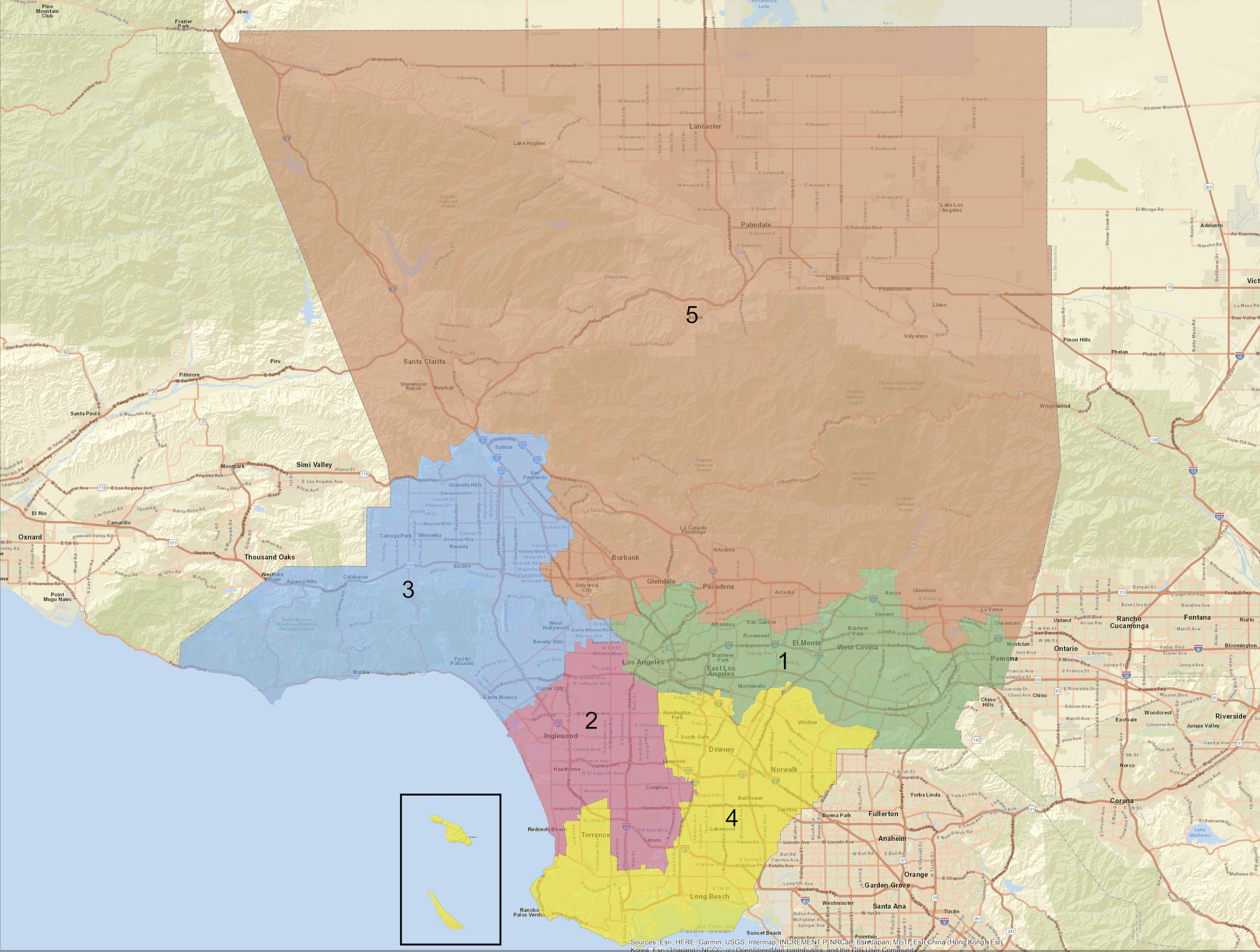
| High Resolution Image of Final Map | Click Here to Download (PNG) |
| List of Cities and Communities by Supervisorial District | Click Here to Download (Excel) Click Here to Download (PDF) |
| Final Map Shapefile | Click Here to Download (Zip File) |
| RDU Block Equivalency Table | Click Here to Download (Excel File) |
| Block Equivalency Table | Click Here to Download (Text File) |
| Resolution Adopting Redistricting Plan (adopted 12/15/2021) | Click Here to Download (PDF) |
| Resolution Adopting Redistricting Report (adopted 12/15/2021) | Click Here to Download (PDF) |
Draft Map Options Chosen by Commissioners for Further Public Input and Discussion
| File Name | Download Link |
|---|---|
| Option A | Click here to download Shapefile |
| Option A-1 | Click here to download Shapefile |
| Option B | Click here to download Shapefile |
| Option B-1 | Click here to download Shapefile |
| Option B-2 | Click here to download Shapefile |
| Option B-3 | Click here to download Shapefile |
| Option B-4 | Click here to download Shapefile |
| Option C | Click here to download Shapefile |
| Option C-1 | Click here to download Shapefile |
| Option D | Click here to download Shapefile |
| Option D-1 | Click here to download Shapefile |
| Option E | Click here to download Shapefile |
| Option F | Click here to download Shapefile |
| Option F-1 | Click here to download Shapefile |
| Option F-2 | Click here to download Shapefile |
| Option F-3 | Click here to download Shapefile |
| Option F-4 | Click here to download Shapefile |
| Option G | Click here to download Shapefile |
| Option G-1 | Click here to download Shapefile |
Submitted Draft Maps
| Draft Number | Submitter | Download Link | Submitter’s Comments |
|---|---|---|---|
| OP 001 | Josh Rasmussen | Click to download Shapefile | None |
| OP 002 | Alan Clayton | Click to download Shapefile | “Created two Latino CVAP Districts that meets the U.S. Supreme Court redistricting requirements. Created a District where 20,5% of the population is African American. District 5 has an Asian population of over 25%.” |
| OP 003 | R. Karapetian | Click to download Shapefile | None |
| OP 004 | Stuart Waldman | Click to download Shapefile | “This is a map that shows a San Fernando Valley seat.” |
| OP 005 | Henry Fung | Click to download Shapefile | “A VRA compliant plan which uses the foundation of 2011 Plan T-1 (Molina VRA compliant plan) creating an I-5 focused Latino district, uniting the entire SGV in one district with plurality Latino population and large Asian population, while maintaining” |
| OP 006 | Josh Rasmussen | Click to download Shapefile | “Plan Description: This is a updated plan for LA County redistricting. This map has 3 Latino Section 2 VRA districts (all 51.5+%) as well as protecting a Historically African American district with a Black CVAP of 26%+. In addition this plan tries to minimize city and neighborhood splits and underpopulates the Latino heavy areas with a negative deviation due to the servere undercount in the census.Plan Objectives: This plan creates 3 Section 2 Latino VRA seats with a Latino CVAP of 51.5% for all three. The use of CVAP is very important in LA County since it allows Latinos to elect candidates of choice and this plan meets the first preconditions as laid out in Thornburg v Gingles. This district also protects the historic African American district 2 which in this plan has a CVAP of 26% and can be seen as a Black influence district. District 1 also has a API CVAP of 28% which would unify the Asian population mostly into this district. This plan seeks to minimized city and neighbrohood splits while making this VRA compliant. We also underpopulated the districts impacted by the undercount in the 2020 census thus the high-ish deviation. “ |
| OP 007 | Andrew Westall | Click to download Shapefile | “Plan Objectives: For over 20 years, Latinos in Los Angeles County have been wanting a second Supervisorial District that is majority Latino CVAP. The Board blocked them during that time leading to the creation of this Commission by the State Legislature. This map is built on community boundaries, keeping cities whole, and keeping unincorporated communities whole. The only City split in this plan other than the City of Los Angeles is the City of Burbank and the I-5 Freeway. This is a blueprint for the Commission and the County to avoid costly litigation, which it would lose given the 2020 Census adjusted numbers.” |
| OP 008 | Stuart Waldman | Click to download Shapefile | “Plan Description: This is a plan that keeps the San Fernando Valley mostly whole with the tri-cities of Burbank, Glendale and Pasadena. It keeps the Valley cities of Hidden Hills and Calabasas with their COG in another district.Plan Objectives: This plan keeps the San Fernando Valley mostly whole. It keeps the Valley cities of Hidden Hills and Calabasas with their COG in a different district. It includes the tri-cities of Burbank, Glendale and Pasadena.” |
| OP 009 | Henry Fung | Click to download Shapefile | “Plan Objectives: This is a plan with four Latino majority districts (total population above 50%) and CVAP percentages of Latinos over 40%, although in no district do they form a majority CVAP. It is provided for discussion purposes only and I do not endorse this plan, but it could be used as a starting point for commissioners who wish to maximize Latino participation. I continue to support OP 005, my original plan.SD 1 and 4 are compact. SD 5 comprises of the core AV cities, the high Latino Northeast San Fernando Valley and Reseda/Van Nuys area, and densely populated Latino first generation immigrant communities in the central city areas like Pico Union, Highland Park, and Macarthur Park. SD 2 connects South LA, the Eastside (East LA and SELA cities), Burbank, Glendale, and Pasadena. In this plan, the Black community which used to be in SD 2 does end up getting cracked into SD 2 and SD 4. The Asian community is evenly split in all districts except 1 where they are about 25% of the population. The Non Hispanic White population forms a majority in SD 3 as it connects the rich coastal cities, Beverly Hills and Malibu, Santa Clarita, and the outer portions of the Antelope Valley.Ultimately, as demographics continue to trend in the current direction with higher fertility among Latinos, older White population, and Black displacement into the Inland Empire and out of state, it is possible that by 2030 these districts, or a slightly tweaked version, could produce not just four majority Latino total population districts but at least three Latino CVAP majority districts.” |
| OP 010 | Kim Lamorie | Click to download Shapefile | “Plan Description: Compact, intuitive maps for all 5 districts. Built using COI Model C as building blocks. VRA-compliant. Plan Objectives: Keeping Communities of Interest together while creating compact, intuitive boundaries. VRA compliant.” |
| OP 011 | Diego Rodrigues | Click to download Shapefile | None |
| OP 012 | The People’s Bloc | Click to download Shapefile | Click here to download attached comments. |
| OP 013 | Carl Fenner | Click to download Shapefile | “Plan Description: Starts with strong proposal from VICA and tweaks to conform with certain Communities of Interest in hillside communities Plan Objectives: Starts with Stwaldman map and makes tweaks to conform with hillside community public comment and Communities of Interest” |
| OP 014 | Mike Roos | Click to download Shapefile | None |
| OP 015 | Faraz Aqil | Click to download Shapefile | “Plan Description: District 1: San Gabriel Valley/East LA District 2: South Bay/South-Central (west of Alameda St./110 FWY, and south of the 10 FWY)/ San Pedro (LA). District 3: San Fernando Valley (West of the 5 FWY) and West LA. District 4: Gateway Cities (Cities South of the 60 FWY, and cities east of Alameda St./110 FWY). District 5: Antelope Valley/Santa Clarita Mountains/Los Angeles National Forest/San Fernando Valley (east of the 5 FWY)/North LAPlan Objectives: District 1: San Gabriel Valley/East LA. District 2: South Bay/South-Central (west of Alameda St./110 FWY, South of the 10 FWY)and San Pedro (LA). District 3: San Fernando Valley (West of the 5 FWY) and West LA. District 4: Gateway Cities (Cities South of the 60 FWY, and cities east of Alameda St./110 FWY). District 5: Antelope Valley/Santa Clarita Mountains/Los Angeles National Forest/San Fernando Valley (east of the 5 FWY)/North LA (including Glendale and Burbank).” |
| OP 016 | Michelle Freridge | Click to download Shapefile | None |
| OP 017 | Mary Kenney | Click to download Shapefile | None |
| OP 018 | Brian Stecher | Click to download Shapefile | “First attempt to create districts that reflect testimony about COI and meet other criteria” |
| OP 019 | Brian Stecher | Click to download Shapefile | “Pie slices from population centroid.” |
| OP 020 | David Holtzman | Click to download Shapefile | “Plan Objectives: This is an adaptation of the People’s Bloc plan, #012. The main difference is that this plan gives some diversity of representation to the North County area, which is very large, and from which the commission heard several requests for diversity of representation, particularly from unincorporated areas contained within or east-south east of Palmdale. [I have a friend in the electoral reform community who lives in a different California county, in the foothills of the Sierra Nevada. A sizeable minority of residents in the area shares her political perspective. But because of where they live, and because districts are drawn to be compact, those residents do not get representation to their liking in the State Legislature or U.S. House of Representatives. My friend often complains about that and longs to have at least one district that stretches from elsewhere to include her residence or a nearby sympatico area, and that might elect a representative to her liking. Just like with North Los Angeles County, a little diversity in representation of the Sierra foothills could be a good thing.] Now that LA County CRC software users can no longer assign official U.S. Census areas (blocks, block groups, or tracts) to districts, and are offered “RDUs” (made-up ReDistricting Units) instead, this is the best I could do. RDU3096 gets in the way of better connections from North County to the southern part of the county. And we would need to use census blocks to “break through” to the unincorporated “hole” in the incorporated city of Palmdale, from which the commission heard at least one request for separate representation (rescue from the city?), without dividing the incorporated city’s population. (RDU3006 is too big to allow that.) The software/database bait-and-switch to RDUs only from the demo version also makes it necessary to take a small part of the populated area of the City of Santa Clarita to draw District 3 here. The part of North County that District 3 here includes is, as the commission heard, largely Latinx and working class, in kinship with much of the population in the rest of District 3 here, as a community of interest. At this point, it would not be practicable for this district to be geographically compact and keep that community connected.”
|
| OP 021 | David Holtzman | Click to download Shapefile | “Plan Description: This starts with OP020 and improves compactness, and perhaps better respects communities of interest and cities. Plan Objectives: This starts with OP 020 and improves compactness, and somewhat better respects communities of interest and cities.” |
| OP 022 | David Holtzman | Click to download Shapefile | “Plan Objectives: Generally OP 020 without connecting the central SF Valley and west coast to the unincorporated areas of Antelope Valley south/east of Palmdale (so no diversity of representation for North County), and with improved compactness and better respect for communities of interest and cities.” |
| OP 023 | MALDEF | Click to download Shapefile | Click here to download attached comments. |
| OP 024 | David Holtzman | Click to download Shapefile | “Plan Description: OP 022 modified to keep a couple more City of Los Angeles communities whole. Plan Objectives: OP 022 modified to keep a couple more City of Los Angeles communities whole.” |
| OP 025 | Bob Huff | Click to download Shapefile | “Plan Objectives: This map was derived from the Commission’s Model C Community of Interest map. The Model C map best represents the nuances of the County and the wishes of the communities made known via public comment, highlighting shared priorities. This map keeps most of the San Fernando Valley in one district while equally breaking up the San Gabriel Valley. The map makes good on racial, economic, political and religious disparities, and ensures a fair chance for equal representation for the demographics within each district. This proposed map corrects many non-linear lines in the current Supervisorial maps, while not disrupting communities that currently lobby/advocate as one voice and leaves them together. The current Supervisorial maps do not need to be drastically redrawn, but slightly amended to correct for population differences and ensure communities are accurately grouped.” |
| OP 026 | Peter Hildago | Click to download Shapefile | None |
| OP 027 | Kim Lamorie | Click to download Shapefile | “Plan Description: Adjusts district boundaries to split fewer cities + COIs Plan Objectives: Creates slightly more deviation of district populations by preventing city/COI splits, per the evaluation metrics tentatively set forth by the Commission” |
| OP 028 | David Holtzman | Click to download Shapefile | “Plan Objectives:I have a friend in the electoral reform community who lives in a different California county, in the foothills of the Sierra Nevada. A sizeable minority of residents in the area shares her political perspective. But because of where they live, and because districts are drawn to be compact, those residents do not get representation to their liking in the State Legislature or U.S. House of Representatives. My friend often complains about that and longs to have at least one district that stretches from elsewhere to include her residence or a nearby simpatico area, and that might elect a representative to her liking. Just like with the Sierra foothills, a little diversity in representation of North Los Angeles County could be a good thing.” |
| OP 029 | Stuart Waldman | Click to download Shapefile | “Plan Description: This map creates 2 Latino VRA seats, an African American seat and keeps the San Fernando Valley whole in one district. Plan Objectives: This map creates 2 Latino VRA seats, an African American seat and keeps the San Fernando Valley whole in one district.” |
| OP 030 | Hailes Soto | Click to download Shapefile | “Plan Description: District 1 – DTLA, NE LA, East LA, SELA, Gateway, Pasadena District 2 – South LA, USC, Inglewood, Hawthorn, Crenshaw, Compton, Watts, Carson, Long Beach District 3 – San Fernando Valley, Burbank, Glendale, Santa Clarita District 4 – Coastal, Malibu, La Virgenes, Santa Monica, South Bay, Peninsula, San Pedro, Wilmington, Hollywood District 5 – San Gabriel Valley, Antelope Valley, Lancaster, Palmdale Plan Objectives: District 1: Kept NE LA, East LA, SELA, Gateway but added Pasadena (had to split the Tri-Cities COI). District 2: Attempted to Keep South LA, Inglewood, Crenshaw, Carson, Long Beach together. District 3: Attempted to keep San Fernando Valley together but added Santa Clarita Valley. District 4: Attempted to keep Coastal and Hollywood Hills region together. Added South Bay, Peninsula, San Pedro and Wilmington together. District 5: Attempted to keep San Gabriel Valley together and included Lancaster/Palmdale/Antelope Valley (had to split Antelope Valley and Santa Clarita COI). “ |
| OP 031 | Marc Jacobs | Click to download Shapefile | “Plan Objectives: This plan does the following: 1. Keeps the SFV almost entirely united (tweaks made based on public comment) 2. Keeps the SGV almost entirely united (tweaks made based on public comment) 3. Uses COI Model C to keep communities together to greatest extent possible 4. Keeps Greater Tri-Cities (Burbank, Glendale, Pasadena) together 5. Keeps SGV Foothills together (except small tweaks to account for existing county services) 6. Maintains a Latino CVAP Majority in District 1 7. Maintains an Opportunity District for African Americans in District 2 8. Creates a new influence/coalition district in District 5 with over 40% CVAP Latino and 20% CVAP Asian” |
| OP 032 | David Holtzman | Click to download Shapefile | “Plan Description: Addresses a possible problem with the Voting Rights Act. Plan Objectives: Addresses a possible Voting Rights Act problem.” |
| OP 033 | Michael Allawos | Click to download Shapefile | “Plan Objectives: Each county District has its own unique overarching social economic interests and this map illustrates this. The San Gabriel Valley wishes to have its own sphere of influence. This map keeps the districts close together without extended small slivers connecting various communities. “ |
| OP 034 | Josh Wheeler | Click to download Shapefile | “Plan Objectives: This modifies the peoples block to keep the San Fernando Valley mostly whole – and puts wealthier affluent portions together. This protects the historic African American seat – and the maintains the 2 Latino majority seats and creates a new SFV-SCV-AV working class district that has a large Latino, Asian and Black population – creating a coalition district.” |
| OP 035 | Faraz Aqil | Click to download Shapefile | “Plan Description: Option D Modified: *The original Option D is the best option when compared to Options A-C because it keeps the region/communities compacted (and not snake-like/gerrymandered), while keeping 2 majority Hispanic Districts. *This modified Option D map fixes several cities/neighborhoods that were split down the middle into different districts (examples: Downey, Watts, Bell Gardens, Bell, Maywood).Plan Objectives: *The original Option D is the best option when compared to Options A-C because it keeps the region/communities compacted (and not snake-like/gerrymandered) *This modified Option D map fixes several cities/neighborhoods that were split down the middle into different districts (examples: Downey, Watts, Bell Gardens, Bell, Maywood), while keeping 2 majority Hispanic Districts. *City of Avalon (and the rest of Catalina Island) was moved from District 2 to District 4 (because District 4 has both San Pedro & Long Beach). Avalon is better with Long Beach than San Pedro because Avalon shares the same school district (Long Beach Unified School District), and is part of the Gateway Cities Council of Governments along with Long Beach.Cities/Neighborhoods that were Moved to:District 1: *Claremont *Glendora *La Verne *San DimasDistrict 2: *Central area *Cloverdale/Cochran area *Korea Town area *Pico-Union area *Watts *West Lake areaDistrict 3: *Chatsworth *Granada Hills *Palms area *Porter Ranch *Venice Beach areaDistrict 4: *Avalon *Florence/Firestone area *Santa Fe Springs *South Whittier area *West Rancho Dominguez Hills area *Willowbrook areaDistrict 5: *Dodgers stadium area *East Pasadena area (to be with Pasadena) *El Sereno *Lincoln Heights *San MarinoWhat I liked about both Option D and this Modified Map: *Still keeps (2) Hispanic Majority Districts: *Downtown LA (kept whole rather than split like a pie) *Port of Los Angeles & Port of Long Beach are kept together. *Burbank-Glendale-Pasadena are kept together in the same district *Most of San Fernando Valley is kept together in 1 District (although areas that are West/East of the 5 FWY are still not together) *Most of San Gabriel Valley is kept together *Most of the Gateways Cities are kept together” |
| OP 036 | Henry Fung | Click to download Shapefile | ” Plan Description: A revised version of People’s Bloc Map A. Note due to technical limitations LAX is in SD 3. It is my intent that LAX be in SD 2 and that Dockweiler Beach be in SD 3. Plan Objectives: Dear Commissioners, please see Revised Map A-1 to address comments I heard from the members of the public and commissioners. Highlights are keeping San Gabriel Valley into only two pieces, reuniting Pomona with SD 1, eliminating the Torrance island in SD 3, and uniting UCLA with its students to the south in Palms. See public comment and/or text file for more detail.
“Benchmark” refers to the original Option A.
SD 1:
SD 1 keeps Azusa whole – there is no reason to split up Rosedale from the rest of Azusa
Same with San Gabriel
SD 1 connects middle income Asian community in SGV – high Asian population areas like Monterey Park, San Gabriel, Rosemead, Alhambra with Rowland Heights and Hacienda Heights (more affluent Asians in SD 5 in cities like San Marino, Arcadia, Temple City, Walnut share more common interests with Whites)
Keeps San Gabriel Valley into only two pieces – Montebello is part of SGVCOG and is moved to SD 1, Industry and Diamond Bar moved to SD 1
Unites Heights communities along Puente Hills
Moves Pomona to SD 1 as requested by Mayor of Pomona
Remains majority Latino (51.59% Latino CVAP compared to 54.52% benchmark map)
Asian representation improves – 25.52% Asian CVAP compared to 22.97% benchmark map
SD 2:
New SD 2 includes renter dominant communities on the Westside – Palms, Sawtelle Japantown, renter heavy portions of Brentwood, Westwood Bl corridor, UCLA campus
Does not split Park La Brea
Includes VA hospital property – many homeless veterans have origins in SD 2
Connects UCLA with many of its students who live in Palms
Keeps the central part of Westchester with SD 2
Unites Japanese American communities in Gardena, Sawtelle Japantown (Little Osaka) and Little Tokyo
SD 2 remains Black influence – 29.79% Black CVAP compared to 30.85% benchmark map
SD 3:
Cheviot Hills is moved to SD 3 due to high homeowner and affluent population to join other high income communities in the Hollywood Hills and Beverly Hills
Keeps Lakeview Terrace in SD 3 while moving Kagel Canyon to SD 5
Cuts at Glenoaks Bl to extent possible to respect Shadow Hills community boundary
SD 3/SD 5 boundary in rest of San Fernando Valley remains the same.
Remains predominantly White – 54.14% White CVAP compared to 54.73% benchmark.
Keeps El Segundo in SD 3
(Note due to technical limitations LAX is in SD 3 when it should be in SD 2)
SD 4:
SD 4 covers all Gateway Cities and SELA
Keeps Long Beach whole
Keeps Whittier whole
Does not include finger to Torrance
Excludes San Gabriel Valley
Watts is moved to SD 4 for population balance and to connect with Florence Firestone – Watts is 62% Latino CVAP, 34% Black so putting it with Latino district helps improve Latino numbers
More Latino – 55.77% Latino compared to 50.15% benchmark map.
SD 5:
SD 5 boundary in NE SFV changes to put Shadow Hills and Kagel Canyon in SD 5 and group more Latino communities in SD 3 with other cities in the Valley
SD 3/5 boundary in rest of SFV remains the same
Duarte is moved to SD 5 as a whole to join its other Foothill cities. Duarte is 44% Latino CVAP and so including it in SD 1 would slightly reduce the Latino percentage in SD 1. Compare with Azusa which is 57% Latino CVAP and should be included in a Latino district.
The underpopulation should as much as possible be in VRA target districts 1, 2, and 4 to reflect the undercount of Latino population in census due to citizenship question uncertainty and lack of language assistance available due to the pandemic, as well as reduced access to technology for Blacks. This does this.”
|
| OP 037 | Mary Kenney | Click to download Shapefile | “Plan Description: Revision to Model D Plan Objectives: This plan modifies Plan D to create a central district with 4 wheel spokes. The central district preserves the East Los Angeles/South Los Angeles hub.” |
| OP 038 | ARCBridge | Click to download Report | Modified Option A – Moved Catalina Island to SD4 |
| OP 039 | ARCBridge | Click to download Report | Modified Option B – Include Bell Gardens with SE LA; keep Burbank together; put Santa Monica in its entirety in SD4 |
| OP 040 | ARCBridge | Click to download Report | Modified Option C – Keep Duarte together; put Van Nuys all together; keep POSO with Sherman Oaks |
| OP 041 | ARCBridge | Click to download Report | Modified Option D – Catalina Island with SD4; include the entirety of Bell, Bell Gardens, and Downey in SD4 |
| OP 042 | Brian Stecher | Click to download Shapefile | “Plan Description: Updated by stecher on 11/8/21 in response to written and oral feedback Plan Objectives: Updated to reflect comments,including adjusting northern SFV, area south of westwood, making Santa Monica and Burbank whole, and adjusting near Lakewood/Cerritos” |
| OP 043 | Kim Lamorie | Click to download Shapefile | “Plan Objectives: This plan accomplishes the following: -Keeps the San Fernando Valley whole -Keeps the San Gabriel Valley whole -Keeps the historically united communities of East LA whole -Keeps the historically united communities of Santa Monica and West LA whole -Keeps the city of Long Beach whole -Keeps SELA whole -Complies with the VRA This map was developed in response to public comment and community feedback, but it leans quite heavily on the COI models developed by the Commission as well as Commissioner statements in order to create as rigorous a product as possible” |
| OP 044 | Mary Kenney | Click to download Shapefile | “Modified Option D to incorporate District 1 from Option A. This supersedes OP 037.” |
| OP 045 | Mary Kenney | Click to download Shapefile | “Plan Description: Change District 1 to conform to District 1 in Option A Plan Objectives: This map replaces District 1 on Draft Map B with District 1 from Draft Map A. It is a combined A/B map.” |
| OP 046 | David Holtzman | Click to download Shapefile | “Plan Objectives: This submission, “A3S Possibility,” gives effect to public commenters desire to have more than one Supervisor representing the north area of the county, and for unincorporated areas near Palmdale to be represented by a different Supervisor than Palmdale’s. It keeps communities of interest together throughout the county, and has three Supervisors representing areas on the Pacific Ocean’s coast. … Because the software currently limits users to Redistricting Units for drawing districts, this submission requires the following adjustments to be considered or adopted as intended: Assign Census Tract 6037930200 to District 3; and Assign Redistricting Units 3023, 3032, 3069, 3070, 3071, and 3091 to District 5 (see A3Spossheart-colored.png).” |
| OP 047 | David Holtzman | Click to download Shapefile | “Plan Description: modifying three stripes
Plan Objectives: This submission, “A3S-2,” is the same as “A3S Possibility,” but has all of Santa Monica in one district and does not split off a small piece below Pico from the West Los Angeles Sawtelle Neighborhood Council area. Like “A3S Possibility” (the “3S” is for three stripes), “A3S-2” gives effect to public commenters’ desire to have more than one Supervisor representing the north area of the county, and for unincorporated areas near Palmdale to be represented by a different Supervisor than Palmdale’s. With this map, north county residents would feel less stranded in a large geographical area if they don’t feel properly represented by the Supervisor whose district they happen to be in. This map keeps communities of interest together throughout the county, and has three Supervisors representing areas on the Pacific Ocean’s coast. Because the software currently limits users to Redistricting Units for drawing districts, |
| OP 048 | aArmen | Click to download Shapefile | “Plan name: 1 Black 2 Latino 1 Asian 1 Valley. Plan Description: This map keeps a 25% Black Seat, 2 50%+ Latino seats, 1 25% Asian Seat and the valley is in one District.” |
| OP 049 | aArmen | Click to download Shapefile | “Plan name: B1 Mod – Valley whole SD5 unites Asian communities Plan Description: This map alters SD1,3 and 5 from Map B1 to unite Asian communities into SD5, SD1 remains Latino CVAP and SD3 unites the Valley Plan Objectives: This plan takes B1 and unifies the Asian Communities in the San Gabriel Valley into SD5, Moves SD1 into Hollywood, and SD3 becomes a San Fernando Valley SD.” |
| OP 050 | Arsi Chan | Click to download Shapefile | “Plan Description: This map is a cleaned-up Option 48 Unifing San Gabriel Communities. SD1 and 4 Is a 50% + Latino District SD2 is a 25% Black CVAP SD5 is 25% Asian (as LA Counties’ 2nd largest minority they should have an opportunity district) SD3 unifies the Valley and unites most of the Armenian Community. Plan Objectives: Looking at Option 48 Map that respected the Asian Community and worked to create an opportunity district. Opt 48 had some flaws that needed to be cleaned up, which this map accomplished. SD1 and 4 are 50%+ Latino CVAP SD5 is 25% Asian CVAP SD2 is 25% Black CVAP and SD3 is San Fernando Valley Majority also unites the Armenian Community the 4th most spoken language minority in the County. This map is not perfect as no map is but can be further refined to meet the needs of the residents of the County and give a more powerful voice to minority communities. “ |
| OP 051 | Josh Wheeler | Click to download Shapefile | “Plan Objectives: This is a modified E with reqests from CM Stecher to united Burbank with Glendale and Pasadena. To do this i had to population balance a bit and pulled some of the wealthier einclaves into SD3. This also creates 2 Latino Maj Minortiy CVAP seat, protects the historic AA Core seat and creates a Coalition district in the 5th that is a plurality Latino with a 40.2 Lation CVAP and is mjority minority (50+) with Asian, Latino, and African American combined. This plan unites the working class portions of the San Fernando Valley with the working class areas of the Antelope and Santa Clarita Valleys” |
| OP 052 | Tigran Sassounian | Click to download Shapefile | “Plan Objectives: This map unifies the Armenian core populations in Glendale, Burbank, Pasadena, the North and East San Fernando Valley into one districts. This also creates two Latino CVAP majority seats in SD1 and SD4 and protects the Black Historic core in SD2. This also links the working class communities of the San Fernando Valley into the Antelope Valley.” |
| OP 053 | David Holtzman | Click to download Shapefile | “Plan Description: Important features of this plan include: – It puts areas most impacted by LAX in the same district as the airport. – It groups large historic communities such as South LA, Southeast LA and East LA in single districts. – It puts the largely working-class heart of the San Fernando Valley in a district with similar communities. – It puts historic Chinatown in the same district as the world-renowned high concentrations of Asian language speakers to the east. – It puts historic Little Armenia in the same district as the burgeoning population of Armenian-Americans and Armenian language speakers in Glendale, Burbank, Pasadena and Altadena. – It gives 3 supervisors beach areas in their districts, distributing opportunities for branding highly visible services such as beach transportation or trash cans. Plan Objectives: Important features of this plan include: – It puts areas most impacted by LAX in the same district as the airport. – It groups large historic communities such as South LA, Southeast LA and East LA in single districts. – It puts the largely working-class heart of the San Fernando Valley in a district with similar communities. – It puts historic Chinatown in the same district as the world-renowned high concentrations of Asian language speakers to the east. – It puts historic Little Armenia in the same district as the burgeoning population of Armenian-Americans and Armenian language speakers in Glendale, Burbank, Pasadena and Altadena. – It gives 3 supervisors beach areas in their districts, distributing opportunities for branding highly visible services such as beach transportation or trash cans.” |
| OP 054 | Arturo Gomez | Click to download Shapefile | “Plan Description: D-1: Eastside communities, Latino SGV cities, northern gateway cities, as well as dense Central LA neighborhoods. D-2: Black and Latino neighborhoods centered south of the 1-10, as well as the southeast gateway cities. D-3: Communities of Crescenta Valley and SFV, the City of Glendale, and cities and communities surrounding the Santa Monica Mountains. D-4: Westside, beach, and South Bay communities and Cities. D-6: Antelope and Santa Clarita Valleys, and most of SGV Plan Objectives: D-1: Eastside, NELA, Central LA, Latino SGV, and Northern Gateway Cities. D-2: Black and Latino communities south of the I-10, Culver City, Southeast Gateway Cities, and Latino South Bay communities. D-3: United Crescenta and San Fernando Valleys, City of Glendale, communities surrounding Santa Monica Mountains. D-4: South Bay and Palos Verdes Cities and communities, Westside Cities and communities. D-5: Antelope and Santa Clarita Valleys, Angeles National Forest, and most of SGV.” |
| OP 055 | Raul Jaurgui Volpe | Click to download Shapefile | “Plan Objectives: This map improves Map Options A and F by incorporating input from the San Fernando Valley, Westside, and South Bay communities. This map took Map F as a baseline. Changes: -Moves Woodland Hills to SD3 -Moves Hidden Hills to SD3 -Moves Beverly Hills and West Hollywood to SD2 -Moves Rancho Palos Verdes to District 4 MAINTAINS DISTRICT 1 AS ADVOCATED BY THE PEOPLE’S BLOC SUBSTANTIALL MAINTAINS DISTRICT 2 and 4 IN A WAY THAT DOES NOT FUNDAMENTALLY CHANGE THE DEMOGRAPHIC BALANCE IN THOSE DISTRICTS Note: we have heard extensive testimony to have the coastal communities and SFV in separate districts. However, if the commission decides a Map A-based option is the final decision, this map would correct for the lack of our community’s voices in the People’s Bloc process. The People’s Bloc should be applauded for accurately capturing the perspective of Eastside residents. They did not however consult all the communities of LA County that they claimed to. Please look at the public comments they submitted and you will find zero input from the residents of their proposed District 3.” |
| OP 056 | Makeda | Click to download Shapefile | “Plan Objectives: -Unites LVCOG (COI) -Puts Woodland Hills in SD 3 where it belongs (COI) -Puts Rancho Palos Verdes in SD 4 where it belongs (COI) – Keeps LAX in SD 3 to keep driving connection for whole district and keep PCH together – Unites Hollywood and West Hollywood (COI) -Puts Pomona in SD5 for compactness” |
| OP 057 | David Holtzman | Click to download Shapefile | “Plan Description: This plan: – Puts large historic communities such as South LA, Southeast LA and East LA in separate single districts. – Puts the historically more working-class, less well-off heart of the San Fernando Valley (SFV) in a district with similar communities, and not with most of the wealthy Westside. – With a majority-SFV district, could facilitate election of a Supervisor who lives in the SFV. – Puts a sizable area with concerns about childhood cancer and exposure to toxins from the Santa Susana Field Laboratory in a district adjacent to the area of Ventura County containing the lab. (See MSNBC’S “In the Dark of the Valley.”) – Puts areas most impacted by LAX in the same district as the airport. – Gives 3 districts beach areas, distributing opportunities among supervisors to provide highly visible beach-related services (such as transportation, clean facilities, and attractive trash cans), especially for county-managed beaches. – Puts inland African American communities of interest in the same district as Bruce’s Beach. – Puts historic Chinatown near DTLA in the same district as very large Asian ancestry/language communities of interest (and restaurants) in the San Gabriel Valley. – Puts historic Little Armenia in the same district as the Armenian-ancestry/language community of interest in and around Glendale, Burbank, Pasadena, and Altadena. – Respects the topographic division imposed by the San Gabriel Mountains.” |
| OP 058 | Brian Stecher | Click to download Shapefile | “Plan Description: Modifications of B.1 that extend D2 south and make other changes suggested during discussion on Nov 15 Plan Objectives: Revision of B.1 that makes District 1 like map A.1, modifies D2 to capture more of historic African-American central city and keep LAX, keeps Burbank, Glendale and Pasadena together, moves some of NE SFV into D5, and keeps districts relatively compact.” |
| OP 059 | Arsi Chan | Click to download Shapefile | “Plan Objectives: Took Map 50 an iteration of Map B and parts of Map A. Did the recommendations of the Chair take Beverly hills into District 3, Unified communities of Watts etc. into district 2. and minor clean-up keeping communities together. “ |
| OP 060 | Arsi Chan | Click to download Shapefile | “Plan Description: This map modified Map 50 to keep Watts, Lynwood, Compton etc into District 2, but still keeps District 5 as an Asian influence seat with son SGV communities cleaned up. Moving AZUSA to District 1 and Beverly Hills into District 3… Plan Objectives: Modified B/50 Cleaned up District 1 by moving Beverly Hills into District 3. Unifying Watts, Lynwood, Compton, Histicic NCs etc. into District 2 Cleaning up SGV to unite communities but keep as Asian Influence district. “ |
| OP 061 | Arsi Chan | Click to download Shapefile | “Plan Objectives: This map takes the previous map modification (done tonight) and unites Glendale Burbank and Pasadena.” |
| Op 062 | MALDEF | Click to download Shapefile | “Amendment 1 oConcerns addressed: Long Beach whole (within BOS2); Burbank placed in district with Glendale and Pasadena (within BOS5); The 101 freeway is used to connect the East SFV to the Southeast cities, instead of the 5 freeway; Florence-Graham added to the Southeast Cities; South Gardena paired with Torrance in BOS4 (split at Marine Ave.) to maintain Asian COI. Consequences; Less of an Asian influence in BOS5; More of a three way split of SFV. ·Amendment 2 oConcerns addressed: Long Beach whole (within BOS4); Burbank placed in district with Glendale and Pasadena (within BOS5); The 101 freeway is used to connect the East SFV to the Southeast cities, instead of the 5 freeway. Consequences: Less of an Asian influence in BOS5; More of a three way split of SFV; Koreatown moved to BOS2, split away from Chinatown, Thai town, Filipino town, and Little Tokyo. ·Amendment 3 oConcerns addressed: SFV split among only 2 districts, instead of 3 districts; Long Beach whole (within BOS4); Burbank placed in district with Glendale and Pasadena (within BOS5); The 101 freeway is used to connect the East SFV to the Southeast cities, instead of the 5 freeway. Consequences: Diamond Bar to Malibu; No Asian influence in BOS5; More of a three way split of SFV; Koreatown moved to BOS2, split away from Chinatown, Thai town, Filipino town, and Little Tokyo.” |
| OP 063 | Henry Fung | Click to download Shapefile | “Plan Description: Map F-1 Revised – SFV One District is a modified map designed to take the complaints of the San Fernando Valley and keep them in one district as much as possible. It also meets the Armenian community desire to attach North Hollywood to their communities of interest to the east in Burbank and Glendale.Plan Objectives: Map F-1 Revised – SFV One District is a modified map designed to take the complaints of the San Fernando Valley and keep them in one district as much as possible. Unfortunately, you can’t keep them in one district and have enough for the North County to attach themselves to the remaining cities in the foothill communities. Also, the Armenian community expressed an interest to attach North Hollywood to their communities of interest to the east in Burbank and Glendale.This map does the following: SD 1 stays the same as previous in the San Gabriel Valley except moves Covina to SD 5 to meet with their city elected official’s request as stated in their letter to the commission and in comments at a San Gabriel Valley COG meeting. Covina has historically always been in SD 5 in the 1991, 2001, and 2011 redistrictings, unlike Walnut which was in SD 5 in 1991 and in SD 1 in 2001 and 2011 and so was not moved. It also adds La Habra Heights. On the City of LA side it keeps Pico-Union whole by jutting west north of the 10 freeway.SD 1 now links Chinatown with Little Tokyo, adds Koreatown, and connects all to the Asian communities along the 10 and 60 corridors. It also adjusts the northern boundary to match the Glendale/LA City limit in response to commissioner Obregon’s concerns. It adds La Habra Heights and Pico Rivera for population balance. Pico Rivera was a member of the ACE Construction Authority and has connections to SGV interests such as the Whittier Narrows and railroad traffic so it is not unusual to add them to a SGV focused district. It connects Sunset Junction and Silver Lake and does not split this historically LGBT community.SD 2 keeps the Westside Neighhborhood Council whole and regularizes the boundary to cover the portions of Mid City with a significant Black population. It now stretches to the coast so that the South Bay COG is only split into two pieces. It does not have an odd strip connecting through Dockweiler Beach. Blacks remain the second largest group at about 27% compared to 30% in the baseline map so they remain able to influence their supervisor. It includes Watts, South Central, Ladera Heights, Crenshaw, Inglewood, and Compton, the core of the Black community. South of the 10, it cuts off at the 405 freeway (with the exception of Culver City’s extension to the west) as communities west of the 405 tend to be more affluent. It continues to maintain a community of interest along UCLA and covers denser communities of Sawtelle Japantown, Palms, and West Los Angeles near the Expo Line and 405 freeway heavily populated by UCLA students. Although the Beach Cities are also affluent this is more compact and does not take them on a district all the way to the San Fernando Valley. In Downtown LA it regularizes the boundary along 5th Street.SD 3 consists of the San Fernando Valley west of North Hollywood, the Las Virgenes/Malibu COG, Santa Monica, Venice, Mar Vista, Playa Vista, homeowner rich areas of the Westside and areas west of the 405, West Hollywood, Hollywood, Marina Del Rey, the Miracle Mile, Park La Brea, and Beverly Hills. It keeps as much of the SFV as whole as possible while respecting the carveouts requested by members of the community. It does connect some communities south of the hill but they will not be the largest influence and the SFV will be the majority of this district, and does not go south of the airport.SD 4 consists of the SELA communities and the Gateway Cities except Pico Rivera. It also has the Palos Verdes Peninsula. Although not ideal, they are better suited to SD 4 than SD 2 to not further dilute Black influence in SD 2. It keeps Long Beach whole and now includes Lomita, which is more of a working class community tied into the ports than the beach cities to its west. Lomita is also part of LAUSD and Narbonne High School in Harbor City serves Lomita. It includes Carson for population balance and relatively high Latino population (32% CVAP). If it is desired to strengthen the Black CVAP in SD 2 the City of Carson Council District 1 (generally consisting of the part of Carson north of the 405 freeway and Del Amo Boulevard) could be placed in SD 2 and the rest stay in SD 4.SD 5 consists of the foothill cities, north County, and links Armenian-American dominant communities of North Hollywood, Burbank and Glendale. It links the tri cities of Burbank, Glendale, and Pasadena together. It links the 210 corridor together except for Azusa, which is grouped with central SGV cities in the state legislative district maps because of commonality of interest. It places Shadow Hills and Kagel Canyon in a more rural district. For population balance it includes the Los Feliz and Griffith Park neighborhoods, as well as the Hollywood Hills and Hollywood east of the 101 freeway.It maintains two CVAP Latino districts (1 and 4 at 53.25% and 51.17% respectively), one Black influence district (2 at 27.16%, after Latinos at 34.56% and above Whites at 25.25%) and creates an Asian influence district (1 at 26.72%).It is more compact than original F-1 on the western edge and central city, with more regular boundaries other than the UCLA extension.A pro or con is that it splits the coastline into three districts. This could mean more focus on the coast, or a situation where the coast is neglected because there is no champion.It should also be noted that due to the use of Redistricting Data Units it is impossible to make clean cuts at freeways or neighborhood council boundaries. Commissioner Holtzman’s comments should be addressed in the 2031 cycle. “ |
| OP 064 | CRC Ad Hoc Working Group | Click to download Shapefile | Click here for details on changes and reasons. |
| OP 065 | CRC Ad Hoc Working Group | Click to download Shapefile | Click here for details on changes and reasons. |
| OP 066 | CRC Ad Hoc Working Group | Click to download Shapefile | Click here for details on changes and reasons. |
| OP 067 | Henry Fung | Click to download Shapefile | “Plan Description: Map 66 with changes at Hollywood/Koreatown boundary, SFV edges, Pomona/Claremont. Plan Objectives: I support Map 66 with the following changes: Move Armenian dominant communities in the City of Los Angeles (Little Armenia, North Hollywood) to SD 5. Unify Burbank and LA Toluca Lake in one district. Move Koreatown to SD 1. Add Montebello to SD 1 so to not split the San Gabriel Valley into three districts (Montebello is in San Gabriel Valley COG). Move the small unincorporated area west of Towne and south of Foothill next to Pomona and Claremont into SD 5 (it has a Claremont zip code and the community of interest it is closest linked to is Claremont – Richbrook and Foxpark Drives). Move Granada Hills, Porter Ranch, and Chatsworth to SD 3 (make SD 3 boundary consistent with City of LA boundary). Move La Tuna Canyon into SD 5 to join other rural communities like Shadow Hills and Kagel Canyon. Move Lakeview Terrace back to SD 3 for commonalities south of the 210 freeway. Boundaries were adjusted in Koreatown and Hollywood for population balance, to keep LGBT community in Sunset Junction/Silver Lake together, and to normalize boundaries to match arterials to the extent possible given use of Redistricting Data Units. This is reflected as Map 66.1. “ |
| OP 068 | Faraz Aqil | Click to download Shapefile | “Plan Description: This map makes changes to the submitted OP 064 map (which was a B-1 modified map by the Ad Hoc Working Group). Summary of Changes: 1) Tujunga-Chatsworth area moved between District 3 & 5, 2) The narrow 110 FWY stripe south of Gardena is compacted with District 4, 3) Made the Westside region more whole by moving LA Neighborhoods from District 4 to District 3. Plan Objectives: *Moved Tujunga (LA), Sunland (LA), Kagel (unincorporated) areas into District 3 (to connect with the San Fernando Region). *Moved Sylmar (LA), Granada Hills (LA) and Chatsworth (LA) into District 5 (to be connected with Porter Ranch [LA] at base of the Mountain). *I moved the narrow strip of LA area south of Gardena that runs along the 110 FWY (Harbor Gateway [LA]), into District 4 in order to make District 2 more compact & to make District 4 more connected. *Moved Downtown LA area (West of Alameda St.) to District 2. But moved Chinatown (LA) to District 1. *Lastly, to make the Westside region more whole, I moved the following LA Neighborhoods out of District 4 and into District 3: Park LA Brea, Mid-City, Miracle Melle, Cloverdale/Cochran, Longwood, South Carthay, Crestview.” |
| OP 069 | Mary Kenney | Click to download Shapefile | “Taking Plan 66, I moved the Palos Verdes Peninsula into District 2, as Palos Verdes should be kept with Torrance. I moved Carson to District 4 and Sylmar to District 5 in order to meet the range check (each district must be approximately 2 million). Because the population of Palos Verdes is relatively small, the ethnic makeup of the 5 districts is not materially changed.” |
| OP 070 | David Holtzman | Click to download Shapefile | “Plan Description: PV with the Beach Cities Plan Objectives: I have been listening to and reading public comments, and making adjustments to my most recent previously submitted map (plan), OP 057 (David Holtzman) — PLEASE SEE DESCRIPTION THERE. The objective here is to satisfy the statutory criteria with an improved (“EvenEvenEvenMoreBetter”) map that responds to more public input. Also please note: this map (plan) includes the Palos Verdes peninsula in the same district as the South Bay’s Beach Cities.” |
| OP 071 | Arsi Chan | Click to download Shapefile | “Plan Description: This map modifies Map 66 to:U 1. Unite the Historic Jewish communities in the Westside into SD3, 2. Unified the Armenian community of the SFV to Glenade-Burbank. 3. Moved Palms. Del Ray NC and Marina Del Ray into SD 3 with Santa Monica etc. increased Black CVAP in SD2 and Latino CVAP into SD1 Plan Objectives: This map modifies Map 66 to: 1. Unite the Historic Jewish communities in the Westside into SD3, 2. Unified the Armenian community of the SFV to Glenade-Burbank. 3. Moved Palms. Del Ray NC and Marina Del Ray into SD 3 with Santa Monica etc. increased Black CVAP in SD2 and Latino CVAP into SD1” |
| OP 072 | Arsi Chan | Click to download Shapefile | “Plan Objectives: need to brake up RDU of LAX and put into SD2.” |
| OP 073 | Arsi Chan | Click to download Shapefile | “Plan Description: Unite Sylmar with other Latino communities in SFV and move NoHo and other Armenian communities with Burbank/ Glenade Plan Objectives: Unite Sylmar with other Latino communities in SFV and move NoHo and other Armenian communities with Burbank/ Glenade” |
| OP 074 | Arsi Chan | Click to download Shapefile | “Plan Description: This map takes the best parts of maps 60 and 66 and unites them to create a map with: SD2 picking up the LAX, UCLA, Beach communities, the Palos Verde area etc and still almost 25% Black CVAP; SD3 Unites the San Fernando Valley COG communities; SD4 is 53% Latino CVAP; SD1 Unites the Eastside Communities of Los Angeles and Hollywood with working-class communities in the San Gabriel Valley; SD5 becomes a 25% Asian district combining the Foothill communities and the North County. Plan Objectives: This map takes the best parts of maps 60 and 66 and unites them to create a map with: SD2 picking up the LAX, UCLA, Beach communities, the Palos Verde area etc and still almost 25% Black CVAP; SD3 Unites the San Fernando Valley COG communities; SD4 is 53% Latino CVAP; SD1 Unites the Eastside Communities of Los Angeles and Hollywood with working-class communities in the San Gabriel Valley; SD5 becomes a 25% Asian district combining the Foothill communities and the North County.” |
| OP 075 | David Holtzman | Click to download Shapefile | “Plan Objectives: This is an option for connecting North County in two pieces via reasonable roadway routes. This would provide separate supervisorial representation for the Santa Clarita area and the Palmdale-Lancaster area. It incorporates many of the insights/purposes used in maps I submitted previously. … Per Stuart Waldman’s SFV shapefile, 55.80% of the population of District 3 in this plan is in the San Fernando Valley.” |
| OP 076 | David Holtzman | Click to download Shapefile | “Plan Objectives: This updates OP 070 to add more of the San Fernando Valley (mainly the hillside areas of Sherman Oaks and Studio City) to District 3, giving the Valley a stronger majority of District 3’s population. In so doing, it includes all of the Southeast subregion of the Valley (as shown in the report Stuart Waldman submitted with a SFV reference layer shapefile — see https://redistricting.lacounty.gov/mapping-files-data-download/) in District 3. … Minor changes highlight District 5’s highway connections between North County and the West SFV, Las Virgenes, and the Westside of Los Angeles. … Per Stuart Waldman’s SFV shapefile, **67.75%** of the population of District 3 in this plan is in the San Fernando Valley.” |
| OP 077 | Brian Stecher | Click to download Shapefile | “Plan Description: To bring population within allowed deviation and make other minor corrections consistent with other maps. Move Montebello from SD4 into SD1 Move La Habra Heights from SD1 into SD4 Move Playa Vista, and the area east of Marina del Rey from SD3 into SD2 Plan Objectives: To bring F-1 into compliance. Three small changes: Move Move Montebello into SD1. Move La Habra Heights into SD4. Move Playa Vista and the area east of Marina del Rey into SD2. It wasn’t necessary to move anything else from SD3 to SD2.” |
| OP 078 | Arsi Chan | Click to download Shapefile | “Plan Description: This map modifies 74 to make sd2 it more like G, still using of maps G & 60 to create a map with: SD2 has LAX, UCLA, Beach communities, the Palos Verde area etc and still almost 25% Black CVAP and keeping historic black NCs SD3 Unites the San Fernando Valley COG communities SD4 is 53% Latino CVAP SD1 Unites the Eastside Communities of LA & Hollywood with working-class communities in the San Gabriel Valley SD5 becomes a 25% Asian district combining the Foothill communities of SGV & the North” |
| OP 079 | Hailes Soto | Click to download Shapefile | “Plan Description: Modified Option G. Moved City of Commerce and City of Pico Rivera from SD4 to SD1 (Montebello is already in SD1). Moved City of Carson from SD4 to SD2. Moved Sylmar from SD5 to SD3. To balance populations within proposed districts, moved City of Azusa from SD1 to SD5 and moved South LA neighborhood located west of the City of Huntington Park (roughly zip code 90011) from SD2 to SD4.’ |
| OP 080 | Bob Robertson | Click to download Shapefile | “Plan Description: This map takes Map 78, a map that is good but had a few areas that needed improvements. Changes to the map include: 1.The Palos Verdes area is moved to be with San Pedro and Longbeach. 2. other small adjustments to this map. Plan Objectives: This map takes Map 78, a map that is good but had a few areas that needed improvements. Changes to the map to include the Palos Verdes area is moved to be with San Pedro and Longbeach. Other small adjustments to unify divided communities. “ |
| OP 081 | The People’s Bloc | Click to download Shapefile | “These changes increase the Latinx CVAP in SD 1 to 53.02% with an Asian CVAP of 24.29%. It also keeps SD4 at a 51.51% CVA. The changes also lower the underpopulation within SD4 and SD1. “ |
| OP 082 | CRC Ad Hoc Working Group | Click to download Shapefile | Click here to view synthesized input from public hearing no. 3 with notations on changes made in ad-hoc working groups. |
| OP 083 | CRC Ad Hoc Working Group | Click to download Shapefile | Click here to view synthesized input from public hearing no. 3 with notations on changes made in ad-hoc working groups. |
| OP 084 | CRC Ad Hoc Working Group | Click to download Shapefile | Click here to view synthesized input from public hearing no. 3 with notations on changes made in ad-hoc working groups. |
| OP 085 | David Holtzman | Click to download Shapefile | “Plan Objectives: This update of OP 076 responds well – as well as I could, I think – to comments and discussions I’ve heard or seen recently. … For instance, it puts Pico Rivera and Commerce in the same district as Montebello. … It puts Lynwood in the same district as the other cities in the SELA Alliance. … It adds the Wholesale District south of I-10 to that district, pairing it with SELA’s Vernon, which likewise is largely engaged with large-scale movement and sales of goods. … It puts Carson in proposed District 2. … It keeps together a significant portion of the San Gabriel Mountains foothills. … And it has a district with 68.43% of its population in the San Fernando Valley. … … … NOTE: The Commission still may (and should) consider connecting Santa Clarita and North County in general to other parts of the County over land that runs along the western border of the County, rather than over the high mountains and through the vast expanse of the Angeles National Forest.” |
| OP 086 | David Holtzman | Click to download Shapefile | “Plan Objectives: OP 078 (from another author) with many improvements.” |
| OP 087 | Stuart Waldman | Click to download Shapefile | “VICA Recommended Changes to Ad Hoc Option G. Plan Description: This map moves Alhambra, Monterey Park, Rosemead, San Gabriel, East San Gabriel and Temple City to SD 5. It unites the Hollywood NCs of Hollywood Hills, Hollywood United, Central Hollywood, Hollywood Studio District, and Central Hollywood into SD 1. Unites Granada Hills North, Granada Hills South, Northridge West, Northridge East and Northridge South in SD 3.” |
| OP 088 | Arsi Chan | Click to download Shapefile | “Plan Description: Since the issue with Map 78 was Pomona not in SD 1 this map is able to accomplish that with keeping 2 latino CVAL, a Black CVAP and an Asian CVAP district. Plan Objectives: As the commissioners feel that Pomona should stay in SD1 at all costs please see this modified map that works for the SFV, with an Asian influence district in SD5, SD1 and 4 Latino CVAP, SD2 Black CVAP and SD3 SFV” |
| OP 089 | Arsi Chan | Click to download Shapefile | “Plan Description: Changes from Map B3: * Unite the “Southern Railroad Communities” That have been impacted by traffic and Rail from the Port with the Ports. That is Huntinghon Park, Maywood, Bell, Cudahy, South Gate, Bell Gardens, Paramount, and Florance- Firestone, with Ports in SD4 *Mover SD2 North to Pick up UCLA and adjust for population *Moved SD3 to unify the LA City portions of SFV with Burbank as they share a LA Community college district. *Unified Hollywood in SD1 *SD5 unified SGV north of 10″ |
| OP 090 | Arsi Chan | Click to download Shapefile | “Plan Description: This map modifed F2: 1Unified West Side NC into SD2 2Only 2 SD in SGV Plan Objectives: This Map Modifies F2 to 1. Unify the Westside NCs with UCLA in SD2 2. Put LAX into SD2 3. Move more of SFV into SD3” |
| OP 091 | Arsi Chan | Click to download Shapefile | “Plan Objectives: This Map modified map G: Keeping Pomona in SD1 with most of East SGV and North East LA. as a 53% Latino District. SD4 keeps Port Cities and the Environmental Justice Area known as “Southern Railroad Communities” is also 53% Latino CVAP SD2 keeps the historic Black communities together with LAX, USC and UCLA as community assets. SD3 Unifies the SFV SD5 Unifies the westside, and the west foothill communities of the SGV” |
| OP 092 | Andrew Westall | Click to download Shapefile | “Plan Objectives: Keeping like minded communities such as keeping the San Fernando Valley whole as much as possible; Keeping historically connected communities together which increased Black CVAP in District 2 to above 29 percent, while maintaining two VRA Latino Districts.” |
| OP 093 | David Holtzman | Click to download Shapefile | “Plan Objectives: I will explain in a Commission meeting.” |
| OP 094 | Pogos Sala | Click to download Shapefile | None. |
| OP 095 | Brian Stecher | Click to download Shapefile | “Plan Description: Moving Manhattan Beach, etc. into SD4 and out of SD2. Moving other areas from SD4 into SD2 on the east. Moving Pico Rivera from SD4 to SD1 Plan Objectives: Move Redondo Beach, Manhattan Beach and Hermosa Beach from SD2 to SD4. Move Willmington, Florence-Firestone, Huntington Park, Walnut Park, and Vernon (including Bandini Island) from SD4 to SD2. Move Pico Rivera from SD4 to SD1.” |
| OP 096 | Mary Kenney | Click to download Shapefile | “Plan Objectives: This map combines B-4 and F-3. It moves Santa Fe Springs into District 4 from District 1. From Map B-4: it keeps Districts 2 and 3. From Map F-3: it keeps most of District 1, including the northern border of District 1. Whittier, La Mirada, etc. stay as in B-4. In order to keep District 2 from Map B-4, you can move only Santa Fe Springs into District 4.” |
| OP 097 | David Holtzman | Click to download Shapefile | “Using 81- PomonaSplitN-S BGvalley D2BrucesBeach. Connects most of Pomona to D1. The rest could just as easily get constituent services from D1. Puts Burbank and Glendale in the main San Fernando Valley district. Connects D2 to Bruce’s Beach and a bit more of the coast while maintaining sufficient voting/population strength for traditionally united South L.A. communities. Places the Glendale “stub” and NE SFV horse country in D5.” |
| OP 098 | David Holtzman | Click to download Shapefile | “Plan Description: Leaves Pomona intact and with a D1. Adds areas to D5 to meet its need for population, including Monterey Park/Alhambra (one school district) and similar communities to the northeast. Puts Burbank and most Glendale residents in SFV D3. (Includes Glendale “stub” with foothill areas. Has neighing NE SFV horse country in D5 as requested.) Connects D2 to Bruce’s Beach and some more of the coast while maintaining sufficient voting/pop’n strength for traditionally united South L.A. communities. Plan Objectives: Starts with not after, but B-4. 🙂 Leaves Pomona intact and with a D1. Adds areas to D5 to meet its need for population, including Monterey Park/Alhambra (one school district) and similar communities to the northeast. Puts Burbank and most Glendale residents in SFV D3. (Includes Glendale “stub” with foothill areas. Has neighing NE SFV horse country in D5 as requested.) Connects D2 to Bruce’s Beach and some more of the coast while maintaining sufficient voting/pop’n strength for traditionally united South L.A. communities. Conforms to many many good commenter suggestions.” |
| OP 099 | Saira Soto | Click to download Shapefile | “Plan Description: Included San Dimas in SD1; brought in the community directly below Westwood into SD2; the community of interest west of the Canoga Park reserve, and the reserve itself, was moved into SD 5 as they indicated their historic ties to the communities north in SD5. Plan Objectives: keep communities of interest together. Avoid dilution of historically disenfranchised communities’ opportunity to elect a candidate of choice. Meet VRA compliance. “ |
| OP 100 | Pogos Sala | Click to download Shapefile | “Plan Description: This map modified F3 to put: – KTown into SD1 – Valley whole in SD3 with some beach communities – SD2 28% Black CVAP with some of the beach but not all. LAX into SD2 – SD1 and SD4 Latino Plan Objectives: This map Modified F3 to incorporate some of the things in 81, put Ktown into SD1 with other API communities, makes Valley whole, Shares the Beach Communities, Keeps LAX into SD2. “ |
| OP 101 | Maria Khan / The People’s Bloc | Click to download Shapefile | “People’s Bloc F3 Adjusted 12/10/21. Plan Description: This revised version of Map F-3 strives to: Keep the San Fernando Valley whole in SD3 and follow Commission guidance on coastal configurations. Respect SD5 and create an entertainment district, uniting Hollywood, Hollywood Hills, Universal City, Toluca Lake, and Burbank. Unite Asian COIs in SD1, stretching from Thai Town to the East San Gabriel Valley. Take the best from Maps B-4 and F-3 within SD2, bringing B-4’s version of Skid Row and Downtown into F-3’s configuration.” |
| OP 102 | Arsine | Click to download Shapefile | “Map 100 With Valley and Tri-Citys Plan Description: this map modified map 100 puting pasadena with valley” |
| OP 103 | Arsine | Click to download Shapefile | “Map 101 Cleaned up – Plan Objectives: Map 101 had Cal Poly Pomona in SD5 and Pomona in SD1 this unites Cal Poly into SD1. Unified Walnut Island with Walnut Unified San Fernando Valley portions of City of Los Angeles into SD3. Unified Hollywood with Universal and Burbank for entertainment areas. All studios in one district! Hollywood, Burbank, Universal Glenadle” |
| OP 104 | David Holtzman | Click to download Shapefile | “Tri-Cities Together With Valley and Hollywood!! Plan Objectives: Hooray! Revises map OP 098 to put all three of the “Tri-Cities” in a district with the bulk of the San Fernando Valley’s population (although without their long projections into the foothills of the San Gabriel Mountains, which constitute a distinct community of interest). The resulting district (District 3) contains X% of the Valley’s population, and X% of its population resides in the Valley. Parts of this map track F-3 or B-4.” |
| OP 105 | Faraz Aqil | Click to download Shapefile | “Plan Description: Map F-3 is a very good map and is about 99% of the way there. But for that last percent, I wanted to recommend some tweaks to the map based on testimonies/comments and population deviation consideration. Now that Commissioners have narrowed down to 1 map, Commissioners must work to get each District as close to 0% Population Deviation as possible. For reference, our current Supervisor Districts only have at most + or – 31,214 population difference for all 5 Districts. Plan Objectives: Based on testimonies I’ve read, heard, and from my personal opinions, here are my best recommendations on where you should tweak/move cities into these districts: ~District 1: Koreatown (LA), Little Bangladesh (LA), Whilshire Center (LA). This will keep the Asian communities together and compact in District 1 (which already includes Thai Town, China Town, Little Tokyo, and Historic Filipinotown). ~District 2: Torrance. Please keep Torrance with the other South Bay Cities (rather than the Gateway Cities) for better representation. Also: Marina Del Ray (unincorporated), Marina Peninsula (LA), and Playa Del Ray (LA). This is to keep in mind the area’s environmental concerns. ~District 3: West Hills (LA), Lake Manor (unincorporated). To keep as much as the San Fernando Valley together. ~District 4: Commerce, La Habra Heights (unincorporated). ~District 5: Covina, Sun Valley (LA). If Commissioners were to adopt all these recommendations together, the standard deviation will be no greater than + or – 14,260 population (which is no greater than + or – 0.71% deviation). Thank you very much for your time.” |
| OP 106 | David Holtzman | Click to download Shapefile | “Plan Objectives: Expand the media and entertainment area drawn in District 5 on map OP 101 to encompass more of Hollywood and Southeast San Fernando Valley including Studio City.” |
| OP 107 | David Holtzman | Click to download Shapefile | None. |
| OP 108 | Brian Stecher | Click to download Shapefile | “Plan Description: Moved Manhattan, Hermosa and Redondo Beach to SD4. Moved Florence-Firestone and X to SD2. Extended SD2 northward to I-10 Fwy. Plan Objectives: See red polygons [viewable only in software]. Moved Redondo, Hermosa and Manhattan beaches to SD4. Moved Florence-Firestone and Walnut Park to SD2. Extended SD2 on the north including Wilshire Center.” |
| OP 109 | Bryant Edwards | Click to download Shapefile | “Plan Description: -Adds beach cities into 4 -Extends 2 into Westlake and near downtown -Keeps Los Feliz whole -Adds Glendale-adjacent communities into 5 -Moves Whittier communities into 1 -Moves La Verne into 5 Plan Objectives: Commissioners, These revisions seek to: -Keep SELA communities in 4 -Add beach communities to 4 -Address under deviation in 5 -Keep Los Feliz whole -Add Glendale-adjacent communities to 5 -Move Whittier and Whittier unincorporated communities to 1” |
| OP 110 | Mary Kenney | Click to download Shapefile | “Plan Objectives: Beach Cities moved to District 4. SELA cities of Huntington Park, Vernon, Maywood, South Gate, Bell, Bell Gardens, Cudahy and Lynwood Island moved to District 2.” |
| OP 111 | Mary Kenney | Click to download Shapefile | “Plan Objectives: Add Beach Cities to District 4. Move Whittier area to District 1. Add Downtown to District 2.” |
| OP 112 | Doreena Wong | Click to download Shapefile | “Plan Objectives: Modifies F-4 in the following ways: SD 1: moves Koreatown, Little Bangladesh and Wilshire Center to SD 1 from SD 2 as some public comments have suggested; moves Commerce and Pico Rivera to keep with other SELA COIs and make up for population balance; SD 2: move Torrance from SD 4 yo SD 2 to keep more beach cities together as requested and keep historic cultural and linguistic, socio-economic interest together (with Gardena and Carson); also add Lomita to SD 2 from SD 4 so more South Bay COG cities together; move Playa del Rey, Marina del Rey and keep Westchester whole (areas around Ballona Wetlands) together in SD 2 from SD 3: move NW corner of SFV and West Hills together; SD 5: keep Sun Valley together” |
| OP 113 | Frank Cardenas | Click to download Shapefile | None. |
 Commissioner Mary Kenney
 Carlos de Alba, Director of Media Strategy